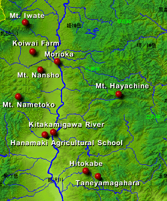
Iwate prefecture is informed by the Ou Mountains, which form the backbone of the Tohoku region, the gentle slopes of the mountainous area of Kitakami, and the Kitakamigawa River basin.
Kitakamigawa, the primary river in the Tohoku region, flows vertically up the middle of Iwate and empties into Sendai Bay. Until the Tokhoku train line opened, the river was central to transport and the transmission of culture. The river basin is more like a wide valley, and serves as the principal agricultural belt in the prefecture.
Several volcanoes stretch along the Ou mountain range, one of Japan's typical volcanic zones, and hot springs bubble up in numerous places at the foot of the mountains. This colorful, variegated mountain range includes the majestic peaks of Mt. Iwate and beautiful forests on the lower slopes of lesser volcanoes.
The Kitakami Mountain Range is the oldest geological feature in Japan. It is thought that this landmass moved up from far south of its present position. After eroding into a peneplain, or a nearly flat land surface, the Kitakami rose up again to become a plateaulike mountain range featuring gently sloping mountains, of which Taneyamagahara is particularly well-known, and little valleys.
| [Kitakamigawa River] |
 Number Map 250(Akita, Morioka, Shinjo, Ichinoseki) FD Map(5839, 5841, 5939, 5941) |
|
|
The Local Climate and Kenji's Works |
|
Top Page |
